Today was an enforced rest day. The weather saw to that! There was heavy rain for the entire day. It had been in the forecast for a while, so although unwelcome, it was not unexpected.
We had a quiet morning, catching up on writing and tidying up. We also discovered that Garmin have just released new versions of their top end power measuring pedals, cycling GPS head units, and fitness watches. Much discussion ensued about possible future purchases and 'trickle down' existing hardware from father to son!
We went into Bourg d'Oisans for a late lunch, which turned out to be burgers and coffee at 'Les Négociants', the restaurant next to the bike shop. The name, by the way, translates as 'The Merchants'. Needless to say, it was excellent.
We spent the rest of the day at the rather superb museum at the EDF Hydroelectric plant on Lac Verney. It's quite niche, but if you like engineering and a little history, is well worth a visit. It's all free, but you do need photo id to borrow the audio equipment which gives a commentary on each part of the exhibition. We started off using this, but after a while were able to translate most of the information from the displays themselves, which was in French.
We prepared the bikes for tomorrow. If all is well, and the weather holds, Andrew is going to attempt the Lautaret.
We had a leisurely evening, another of Shawn's excellent dinners, and rounded it all off watching Chris Froome fall off his bike twice in quick succession during highlitghts of the day's Vuelta stage.
Thursday, 31 August 2017
Wednesday, 30 August 2017
Two Old Friends and an Unwelcome Guest
Today should have been the first, and simplest test of whether I'm anywhere near fit enough to be attempting La Marmotte. The idea was to ride over the Col du Glandon, to Saint-Étienne-de-Cuines, then along the valley to Saint-Jean-de-Maurienne. From there, ride back up the Col de la Croix de Fer, and complete the loop, before retracing my steps to Le Clapier. The ride over the Glandon is part of La Marmotte, and the ride back up to the Croix de Fer, while not as big as the Galibier, is a tough enough test in its own right. And it should all have been easily possible within a normal length day.
Things started brightly enough, at around 9:30, with a blast from Le Clapier, along the valley, past Bourg d'Oisans and on to Rochtaille. All the way to Allemont, some 25 km from Le Clapier, the pace was up. The next 25km are not so easy. Once the climb starts properly, after the junction for Vaujany, it is pretty challenging. The gradients are frequently above 8% and my progress was modest, until reaching Le Rivier d'Allemont.
After this village, the road plunges down for a couple of km to cross the valley, before resuming it's relentless gradient once more. It's not until the Lac de Grand Maison is reached, that the road flattens out, and the pace increases. The lake is part of a major hydro electric scheme, and is held back by a very impressive dam. Andrew finally caught me up here, in the car. He'd been doing some shopping.
There is another short downhill section before the road once more kicks up for the final climb to the Glandon. This is where the professional photographers lurk, so it's important to zip up the jersey and smile through the accumulated fatigue!
The ride to the Glandon took about 2 hours 40 minutes, much faster than my previous attempt. After taking on water from the car, and putting on my jacket and video camera, I headed out feeling that this was going to be a good ride and that everything was going to plan. I did have to stop for a couple of minutes just after starting the descent. I kept catching a minibus and having to wait for it. The top of the Glandon is steep and technical, but lower down it opens out. It's a fine descent, which I enjoyed hugely.
At the bottom, in Saint-Étienne-de-Cuines, I removed video camera and jacket, and set out for Saint-Jean-de-Maurienne. We'd stayed here a couple of years ago, and the town brought back fond memories. I picked my way through the town to the famous roundabout with the massive Opinel knife sculpture. And this is where it all started to unravel. On the exit for the road up to the Croix de Fer, was an unassuming orange sign. The key part was 'Route Coupe'. The road is now shut for maintenance until December. There is a diversion, of course, but in a mountainous region, there aren't too many options. In this case, the diversion was over the Col du Mollard, adding distance and a lot of climbing to the ride.
I didn't much care for the Mollard when I rode it in the opposite direction a couple of years ago. A second encounter hasn't changed my view! It's steep throughout, with gradients often approaching 10%, and the road surface is horrid. There are some nice views back across the valley at some points.


The climb seems interminable. It is quite a long way, and the gradients mean slow progress with little respite all the way to the top. A couple of km below the col, the ski resort of Albiez-le-Vieux did at least have a cafe, where I was able to buy a bottle of lemonade and have my bidons replenished.
The descent is also rather nasty. It's technical, and could be fun, but again the road surface is just too horrid.
At the bottom of the descent, I was finally able to get on to the road I'd wanted to use in the first place. Even after slogging over the Mollard, there was still 14km to go to the top of the Croix de Fer. Thankfully the first part of this climb was at lower gradients, and progress was relatively swift. But then as always seems the case, the obligatory ski resort hove into view and road ramped up to 10%. And Saint-Sorlin-d'Arves is not a small resort.
Leaving the top of the resort, I was finally on slightly lower gradients and the kind of rugged terrain that makes these climbs so spectacular.
I made a bee line for the cafe at the top, and bought some lemonade and had my bottles filled. The brand is French, and meant to mimic the sound when the bottle is opened. Its called Pschitt! You can imagine the fun we had with that as a group of schoolboys on a delayed train on the way to a skiing trip in 1966.
A group of classic American motorcycles turned up while I was there. Most unexpected. One of them wouldn't fire up on the kickstart when they were ready to leave. It wasn't much of a problem though, with at least 5km of downhill on which to bump start it!
I was actually shivering as I attached the video camera and headed down. It wasn't until the first uphill section just above the lake when my teeth stopped chattering. There was almost no traffic around, so I quite often used the full width of the road during the descent. The long stretches between hairpins meant that I quite often saw speeds in the region of 60 kph. The 12% climb to get back up to Rivier d'Allemont didn't seem too bad and I was soon gathering speed, until a truck carrying logs pulled out of the forest just ahead. Fortunately it wasn't going far, and I soon sped past as it stopped.
It was a fast an furious run down to Allemont, where I removed camera and jacket and time trialed along the valley, determined not to delay dinner by more than absolutely necessary. As we're the only ones staying here at present, it was fine. I'd been texting Andrew about my progress, and once I'd showered, we were treated to another of Shawn's superb meals.
The Activity for the ride is available on Strava.
Things started brightly enough, at around 9:30, with a blast from Le Clapier, along the valley, past Bourg d'Oisans and on to Rochtaille. All the way to Allemont, some 25 km from Le Clapier, the pace was up. The next 25km are not so easy. Once the climb starts properly, after the junction for Vaujany, it is pretty challenging. The gradients are frequently above 8% and my progress was modest, until reaching Le Rivier d'Allemont.
 |
| View from Rivier d'Allemont |
There is another short downhill section before the road once more kicks up for the final climb to the Glandon. This is where the professional photographers lurk, so it's important to zip up the jersey and smile through the accumulated fatigue!
 |
| The old fool at the top of the Glandon |
At the bottom, in Saint-Étienne-de-Cuines, I removed video camera and jacket, and set out for Saint-Jean-de-Maurienne. We'd stayed here a couple of years ago, and the town brought back fond memories. I picked my way through the town to the famous roundabout with the massive Opinel knife sculpture. And this is where it all started to unravel. On the exit for the road up to the Croix de Fer, was an unassuming orange sign. The key part was 'Route Coupe'. The road is now shut for maintenance until December. There is a diversion, of course, but in a mountainous region, there aren't too many options. In this case, the diversion was over the Col du Mollard, adding distance and a lot of climbing to the ride.
I didn't much care for the Mollard when I rode it in the opposite direction a couple of years ago. A second encounter hasn't changed my view! It's steep throughout, with gradients often approaching 10%, and the road surface is horrid. There are some nice views back across the valley at some points.


 |
| There was evidence of work on the direct route to the Col de la Croix de Fer |

 |
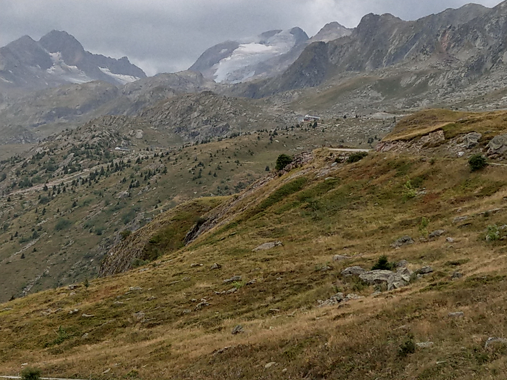
| The Longchamp-1650 ski resort is visible top centre. That is the resort on the route to the Col de la Madeleine |
 |
| The approach to Albiez-le-Vieux |
 |
| Finally made it to the top |
At the bottom of the descent, I was finally able to get on to the road I'd wanted to use in the first place. Even after slogging over the Mollard, there was still 14km to go to the top of the Croix de Fer. Thankfully the first part of this climb was at lower gradients, and progress was relatively swift. But then as always seems the case, the obligatory ski resort hove into view and road ramped up to 10%. And Saint-Sorlin-d'Arves is not a small resort.
Leaving the top of the resort, I was finally on slightly lower gradients and the kind of rugged terrain that makes these climbs so spectacular.
 |
| A couple of km below the Croix de Fer |
 |
| At last. there you are. Where have you been all my life? |
 |
| Made it to the last col of the day. |
 |
| Didn't expect these to turn up while I was there. |
I was actually shivering as I attached the video camera and headed down. It wasn't until the first uphill section just above the lake when my teeth stopped chattering. There was almost no traffic around, so I quite often used the full width of the road during the descent. The long stretches between hairpins meant that I quite often saw speeds in the region of 60 kph. The 12% climb to get back up to Rivier d'Allemont didn't seem too bad and I was soon gathering speed, until a truck carrying logs pulled out of the forest just ahead. Fortunately it wasn't going far, and I soon sped past as it stopped.
It was a fast an furious run down to Allemont, where I removed camera and jacket and time trialed along the valley, determined not to delay dinner by more than absolutely necessary. As we're the only ones staying here at present, it was fine. I'd been texting Andrew about my progress, and once I'd showered, we were treated to another of Shawn's superb meals.
The Activity for the ride is available on Strava.
Tuesday, 29 August 2017
To the Ornon and ... Back!
Today turned out to be rather gentle, which was fine after yesterday's exertions. We did a bit of gentle shopping in the morning, That did result in Alpe d'Huez jerseys for each of us. The perils of visiting a bike shop on holiday! I figured that, having ridden up it three times so far, it was about time to buy some memorabilia. So I got a tee shirt too.
When we got back, we did some more fettling on Andrew's bike. He fitted the 11 speed front mech he bought yesterday, but it still needed some adjustment. Once we'd figured out how to do that, the whole shifting experience was much improved. Time to ride.
We'd already decided that today's ride would be up the Col d'Ornon, to give Andrew experience of something a little less focused than Alpe d'Huez. We finally set off early in the afternoon. A quick blast along the main road and around Bourg brought us past the micro brewery (which wasn't there last time I was here) and to the turn to the Ornon. We headed up.
 |
| The road up the Ornon really does cling to the mountain in places. |
 |
| Andrew managed to make this one look easy |
 |
| The old fool is still having trouble taking selfies |
 |
| All smiles at the top. Chapeau! |
 |
| Nice here init? |
Leaving Bourg and heading back to Le Clapier, I relaxed for a moment and let my mind wander, and the next thing I knew, Andrew had attacked and disappeared off into the distance! It took me several kilometers of hard riding to get back on. Clearly he had some energy left after the climb. And the final indignity was that he did it to me again, on the kick up before the turn to where we are staying. I wasn't willing to follow that one!
I think he's going to be fine on some more climbs this holiday.
The Activity for this ride is available on Strava.
Monday, 28 August 2017
Cool Dude Laughter and the Halibut
After yesterday's trip up to Alpe d'Huez, Andrew wanted to do something flatter today. He ended up doing a 10km run into Bourg and back, and picked up an 11 speed front mech on the way. He also rode to Allemont and did the loop around the lake.
That left me free to ride something a bit bigger than yesterday. So I chose the daddy of them all, and rode up the Galibier. I've not been up it from the Bourg side before. First order of the day was to ride up to the Col du Lautaret, which my phone's predictive text helpfully offered as 'cool dude laughter'. This is a roughly 35 km climb from where we're staying, and has an altitude of 2058 metres. Then there is the small matter of the last 8 km to the top of the Galibier, for which my phone's best effort was 'halibut', at an altitude of 2642 metres.
From Le Clapier to the Barrage du Chambon, the road runs in a steep sided gorge. This is the hardest part of the climb, with gradients up near 9 and 10%. There are also a number of tunnels on this section, with the longest at around 400 metres. These can be quite intimidating, and lights are a must. This year, there is much less traffic on the route, because of the closure of the road above Lac du Chambon. A tunnel collapsed there a couple of years ago. They've had to bore a new tunnel, which won't open fully until December. In the meantime, local traffic is catered for by the 'refuge road'. After the tunnel collapse, the local authorities spent 6.8 million Euros converting a track into the RS1091 road, which runs around the other side of the lake. It's very narrow in part, and even has traffic lights to control traffic in one direction at a time at a point where it literally clings to the side of the mountain. Having ridden it, it was worth every cent! It's full of twists, turns, short steep climbs and descents. It doesn't have an air of permanence, however, so once the new tunnel is complete, there is a chance it will fall into disrepair, and ultimately, the lake!
Rejoining the main road above the problematic tunnel, the gradients ease back for a while, until the road reaches the pretty villages of La Grave and then Villar d'Arene, after a couple more tunnels.
By Villar d'Arenne, the valley has opened right up, with broad vistas on both sides.
The road makes it's way across, broad alpine meadows, finally reaching the Col du Lautaret.
The main road continues down from the Col, towards Italy, by way of Briancon. The road to the Galibier is off to the left. Pausing only for some photos, I headed on up, determined to make this a single ride.
There is definitely less oxygen at this altitude, and I was generating less power, but even so, the fairly unrelenting 6 to 8% gradients weren't really an issue. It goes without saying that the entire ride is spectacular.
At one point there was a herd of cattle grazing at the side of road, and on it.
Once again, despite the altitude and the spiteful 14% ramp just below the peak, I felt pretty good when I reached the top.
The Activity for the climb is available on Strava.
In previous years, it's been particularly cold, and the only order of business after reaching it, was to get down as quickly as possible. This time it was very different. It was warm. I took some photos, and then spent a fruitless half an hour trying to post a Strava update from the top. I could never get the phone coverage and Bluetooth connections to work together long enough to do it, and finally gave up.


I put on a rain jacket and full finger gloves, before finally heading back, and strapped on my small Sony action camera. I have a new chest strap this year, which seems to work better. My arms take up less of the frame! Pausing to allow a group of motorcycles to leave first, I headed back towards the Lautaret. For the first time, I was actually warm! It's a brilliant descent, when you have proper control of the bike. Previous attempts have been a white knuckle ride, punctuated by a fervent hope that it would be possible to operate the brakes at the next corner. No such problems this time. Traffic was light and it was possible to use the entire width of the admittedly narrow road in places. I didn't stop at the Lautaret on the way down, preferring to try and get a single, continuous video down as far as the refuge road. It was great fun all the way down. I even had enough energy to pedal to keep the pace up. The only really scary moment was entering one of the tunnels where the absence of lighting and my sunglasses gave me no visibility at all for a short distance!
Reaching the refuge road, and beginning to overheat, it was time to remove my jacket, and prepare for the final part of the descent. I did stop a couple of times on the refuge road. There are views across the lake that may not be readily accessible in future.
Then it was back into the gorge, and the final plunge back to Le Clapier.
The Activity for the descent is available on Strava.
Epic!
That left me free to ride something a bit bigger than yesterday. So I chose the daddy of them all, and rode up the Galibier. I've not been up it from the Bourg side before. First order of the day was to ride up to the Col du Lautaret, which my phone's predictive text helpfully offered as 'cool dude laughter'. This is a roughly 35 km climb from where we're staying, and has an altitude of 2058 metres. Then there is the small matter of the last 8 km to the top of the Galibier, for which my phone's best effort was 'halibut', at an altitude of 2642 metres.
From Le Clapier to the Barrage du Chambon, the road runs in a steep sided gorge. This is the hardest part of the climb, with gradients up near 9 and 10%. There are also a number of tunnels on this section, with the longest at around 400 metres. These can be quite intimidating, and lights are a must. This year, there is much less traffic on the route, because of the closure of the road above Lac du Chambon. A tunnel collapsed there a couple of years ago. They've had to bore a new tunnel, which won't open fully until December. In the meantime, local traffic is catered for by the 'refuge road'. After the tunnel collapse, the local authorities spent 6.8 million Euros converting a track into the RS1091 road, which runs around the other side of the lake. It's very narrow in part, and even has traffic lights to control traffic in one direction at a time at a point where it literally clings to the side of the mountain. Having ridden it, it was worth every cent! It's full of twists, turns, short steep climbs and descents. It doesn't have an air of permanence, however, so once the new tunnel is complete, there is a chance it will fall into disrepair, and ultimately, the lake!
 |
| The mountains are spectacular. Remind me again why they look like that? Oh yes, water, that's it! |
Rejoining the main road above the problematic tunnel, the gradients ease back for a while, until the road reaches the pretty villages of La Grave and then Villar d'Arene, after a couple more tunnels.
 |
| Not something you see in Hampshire |
 |
| Not far now |
 |
| Right, that's the first bit done |
 |
| Just as well |
There is definitely less oxygen at this altitude, and I was generating less power, but even so, the fairly unrelenting 6 to 8% gradients weren't really an issue. It goes without saying that the entire ride is spectacular.
 |
| That's the Lautaret down there. |
 |
| Reblochon, on the hoof! |
 |
| Are we nearly there yet? Well, yes actually. |
I paid my respects at the memorial to Henri Desgrange, the instigator of the Tour de France, and headed up the final, and steepest kilometer from the tunnel to the summit.
 |
| Chapeau Henri! |
 |
| Made it! |
In previous years, it's been particularly cold, and the only order of business after reaching it, was to get down as quickly as possible. This time it was very different. It was warm. I took some photos, and then spent a fruitless half an hour trying to post a Strava update from the top. I could never get the phone coverage and Bluetooth connections to work together long enough to do it, and finally gave up.

 |
| The road to Italy |

I put on a rain jacket and full finger gloves, before finally heading back, and strapped on my small Sony action camera. I have a new chest strap this year, which seems to work better. My arms take up less of the frame! Pausing to allow a group of motorcycles to leave first, I headed back towards the Lautaret. For the first time, I was actually warm! It's a brilliant descent, when you have proper control of the bike. Previous attempts have been a white knuckle ride, punctuated by a fervent hope that it would be possible to operate the brakes at the next corner. No such problems this time. Traffic was light and it was possible to use the entire width of the admittedly narrow road in places. I didn't stop at the Lautaret on the way down, preferring to try and get a single, continuous video down as far as the refuge road. It was great fun all the way down. I even had enough energy to pedal to keep the pace up. The only really scary moment was entering one of the tunnels where the absence of lighting and my sunglasses gave me no visibility at all for a short distance!
Reaching the refuge road, and beginning to overheat, it was time to remove my jacket, and prepare for the final part of the descent. I did stop a couple of times on the refuge road. There are views across the lake that may not be readily accessible in future.
 |
| Mizoen and the cascade |
 |
| One of the tunnels in the gorge |
Epic!
Sunday, 27 August 2017
Alpe d'Huez with Andrew
The objective, for our first day here, was to get Andrew up to the top of Alpe d'Huez. It's a climb that is tough enough to be a good test of how you are feeling, and a significant achievement if you do manage it. Equally it's not overly long, and it's all literally down hill on the way back.
The day started normally enough, with some bike fettling. After a long day strapped to the back of the car, they had fared remarkably well. A little lubrication seemed all that was required. Even tyre pressures were ok, presumably because the altitude here means that the air pressure is lower, compensating for any loss.
And then Andrew pointed out that his front derailleur was rubbing slightly in bottom gear. An hour and a bit of fiddling and adjustment later, it transpired that when he had upgraded from 10 to 11 speed earlier in the year, he hadn't changed the front mech. Doh! So, we did the best we could in adjusting things, and set out rather later than intended.
The quick blast from Le Clapier to the base of the Alpe went fine, and we stopped for selfies at Km 0, before heading up. Despite all my training rides, and last year in the Pyrenees, I was nervous about whether I'd be able to cope. Once the first couple of ramps were behind us, I started to feel better, and was pedaling quite happily up the inclines with a comfortable cadence in the low 70's, at a couple of hundred watts, and a heart rate in the 140's. Maybe I would be OK this year.
 |
| The scenery here never fails to impress. |


 |
| That lone tree in the centre of the frame just demanded attention! |

Andrew made really good progress up as far as La Garde. This is the toughest section of the climb, with ramps at 10% and sections that are steeper. We were stopping every couple of hairpins, to let him get his breath back, and to re-hydrate. Then, somewhere between La Garde and Huez village, his legs went. From then on, the stops got a little longer, and progress slowed. But at no point did he look like giving up, despite the obvious efforts he was making. He even managed to straighten up and smile for the photographers on the upper hairpins. And he didn't resort to walking, which is more than can be said for the guy in full Giro d'Italia winners kit, who did just that. Awkward!
 |
| The boy done good! |
 |
| Chapeau Andrew! |
 |
| Old fool and his eldest son at the TdF finish line. Perhaps he'll get the hang of selfies eventually! |
The Activity for this ride is available on Strava.
And, I was pretty impressed at the way my phone was able to use auto HDR to capture the events of the day. Chapeau computational photography!
Sunday, 13 August 2017
Photo-Bimble
I went out for a ride this afternoon to get in a few miles, and to take some more photographs to test out the camera on my new phone. It was a bright day, with clouds and sunny spells, so there was lots of contrast on offer. These are pretty challenging conditions for photography.
Here are a few of the resulting frames. These are all straight from the camera, with no post processing. And, naturally, no optical filters were used in the making of these photos.
I'd probably reduce the exposure of the woods, because it was quite dark in there. Here's how the picture looks with the brightness reduced. I just used the Photos app in Windows.

That sky looks threatening!
Just one of many thatched cottages in the area. This one is in North Waltham.


Here are a few of the resulting frames. These are all straight from the camera, with no post processing. And, naturally, no optical filters were used in the making of these photos.
 |
| The Globe pub in Alresford. |
 |
| Bighton Wood |
 |
| Harvested fields between Bighton and Medstead |
 |
| More harvested fields from Common Hill, Medstead |
 |
| Woods near Dummer |
 |
| The woods with reduced brightness |

 |
| Ferns in the verge |
 |
 |
| Combine Harvester above Hunton |

Harvesting is well under way on the Hampshire prairies!

More thatched cottages, this time in Hunton village.

The light at Stoke Charity was gorgeous!
 |
| The Dever at Stoke Charity |
Once again, this photo of the river Dever, flowing through Stoke Charity, looks a little over exposed. Here is how it looks with the brightness reduced.


The pond at Stoke Charity. Exposure in the sky has been held particularly well.

Stoke Charity church.
Overall, these are pretty encouraging. Still seems as though it should be feasible just to use my phone for photos on the rides.
Subscribe to:
Comments (Atom)