- I spent nearly 39 hours cycling
- I covered just shy of 600 kilometres.
- I climbed nearly 18,000 meters vertically, which is over twice the height of Everest above sea level.
- The highest point on trip was the Cime de la Bonette, at 2802 metres above sea level
- The ride with the largest height gain, of 1,986 metres, was over the Telegraphe and the Galibier.
- I expended nearly 19,000 calories while riding.
- My maximum speed while descending, naturally, was 65 kilometres per hour.
- In total, I turned the pedals 123,940 times.
Wednesday, 19 August 2015
Reflections
I've just worked out a few numbers from the last couple of weeks of riding.
New Cleats Please!
I started having trouble clipping in and out of my pedals on the final ride around the vineyards at the foot of Mont Ventoux. When I got back, I decided to buy some replacement cleats. It looks like I really did need them!

Walking around the stones and gravel to get pictures on the climbs probably didn't help either.
Sunday, 16 August 2015
Winding Down
With the climbs all completed, today was a day to wind down, do a little shopping and take a gentle bike tour of the local villages. We bought provisions for tomorrow's dash to the channel. Bedoin was still busy despite this being a Sunday morning. The queue for one of the Boulangeries was impressive.
Then we set up the bikes and headed out for a gentle ride. The terrain is much more like Hampshire, at least in terms of gradients. Nothing quite compares with the clarity of the light through a dry atmosphere. The winds were much stronger today too, though certainly not cold.
The route is roughly triangular, starting out to the south west until Flassan is reached. The area is full of vineyards and plantations of fruit trees. Irrigation is clearly a major concern here, with extensive pipework feeding water directly to the roots of fruit trees.
 Flassan nestles on a hillside a few kilometres from Bedoin.
From Flassan, the route heads south east until it reaches the village of Mormoiron. Again, viticulture dominates the fields. In the main, the buildings have a faintly pink hue, due no doubt to the preponderance of sandstone at lower altitudes.
 The village of Mormoiron is typical of the area, with a very Mediterranean feel to the buildings.
Finally, the route heads north, back to Bedoin. For us this was into the freshening wind. The suggested route steers clear of the inclines of the main road for most of its length, making it a very restful ride.


Then we set up the bikes and headed out for a gentle ride. The terrain is much more like Hampshire, at least in terms of gradients. Nothing quite compares with the clarity of the light through a dry atmosphere. The winds were much stronger today too, though certainly not cold.
The route is roughly triangular, starting out to the south west until Flassan is reached. The area is full of vineyards and plantations of fruit trees. Irrigation is clearly a major concern here, with extensive pipework feeding water directly to the roots of fruit trees.

From Flassan, the route heads south east until it reaches the village of Mormoiron. Again, viticulture dominates the fields. In the main, the buildings have a faintly pink hue, due no doubt to the preponderance of sandstone at lower altitudes.

Finally, the route heads north, back to Bedoin. For us this was into the freshening wind. The suggested route steers clear of the inclines of the main road for most of its length, making it a very restful ride.

Approaching Bedoin from the south, one of the roundabouts has this tribute to cycling, with the observatory on the top of Mont Ventoux in the background.
Arriving back in Bedoin, we passed another winery responsible for producing Ventoux wine, and yet more vineyards.

Some of the extensive vineyards near Bedoin which provide the local Apellation Controllee Ventoux vintages.
And then we were back, and it was time to prepare the bikes for travel and to start packing up for the trip home.
The route for the trip around Bedoin is available on Garmin Connect.
Saturday, 15 August 2015
Mont Ventoux Squared
The final climb on this year's itinerary was to be the mighty Mont Ventoux. There are three ways up the mountain, but the classic one, is from Bedoin, where we were staying. The route starts at the mini roundabout where the D19 and the D974 meet in Bedoin. From there, it follows the D974 all the way to the summit. The first few kilometres is easy, with the gradient rarely going above 5%. However, once the village of Les Bruns is reached, the scene is set for the next 10 kilometres or so. This section, through the Bedoin forest averages 9-10% and is commonly steeper. It is a long, unrelenting climb reminiscent of the hardest parts of the Col d'Agnel. However, as this section is much lower down, it doesn't have the added challenge of less oxygen. It's a hard climb, but never completely taxing. Though the gradients change a bit, the character of this section is constant. The surface is good and there is plenty of shade from both sun and wind. There is no chance to see the summit from within the forest, and little indication, other than the roadside markers, about progress towards the summit.
It's not until you emerge from the forest at Chalet Reynard, with only 6 kilometres still to go, that you finally get to see the summit. Chalet Reynard is a cafe and bar and a popular stopping off point for riders. Many also start the climb to the top from here. Above Chalet Reynard, the gradients drop back until near the top, but the wind becomes a much greater factor. I was lucky that the wind was from the north, which meant I was sheltered from it on many of the ramps. When I did have to ride into it, the effort required increased dramatically, and the temperature dropped too.
 The first clear views of the observatory at the summit don't appear until after Chalet Reynard.
With just 1 kilometre to go, you reach the memorial to British rider Tom Simpson, who died while attempting to climb Ventoux in the 1967 Tour de France. The memorial marks the spot where he collapsed. He died on the way to hospital in a helicopter.Tradition has it that riders bring something up the mountain and leave it at the memorial. I left one of the sweets I've been using as fuel since my energy bars ran out.


It's not until you emerge from the forest at Chalet Reynard, with only 6 kilometres still to go, that you finally get to see the summit. Chalet Reynard is a cafe and bar and a popular stopping off point for riders. Many also start the climb to the top from here. Above Chalet Reynard, the gradients drop back until near the top, but the wind becomes a much greater factor. I was lucky that the wind was from the north, which meant I was sheltered from it on many of the ramps. When I did have to ride into it, the effort required increased dramatically, and the temperature dropped too.

With just 1 kilometre to go, you reach the memorial to British rider Tom Simpson, who died while attempting to climb Ventoux in the 1967 Tour de France. The memorial marks the spot where he collapsed. He died on the way to hospital in a helicopter.Tradition has it that riders bring something up the mountain and leave it at the memorial. I left one of the sweets I've been using as fuel since my energy bars ran out.

Memorial to Tom Simpson who died climbing Ventoux during the 1967 Tour de France.
The final kilometre or so is at 10%, but doesn't seem as hard as the top of the Galibier, Iseran or Cime de la Bonette. Maybe it's because Ventoux is hundreds of metres lower than the really high cols.

For the final time this year, bike and rider at the top of a climb. In the background is the Rhone valley. They say you can see the Mediterranean from here, if you screw your eyes up!

Just as with the Izoard last year, there is a large sweet shop on the top of Ventoux. Actually there are two. Angela bought supplies to help us on the drive back on Monday.

Looking towards the east from the summit. The road is the last couple of kilometres from Chalet Reynard.

As you might expect, with Ventoux dominating the Provence landscape, the views are spectacular.

The observatory can be hard to photograph at the top. Cloud continually comes and goes.
The route up Mont Ventoux is available on Garmin Connect.
To make the trip a circular one, I descended the north side of the mountain, ending up in Malaucene. There are endless debates about which is the harder way up, from Bedoin or from Malaucene. However, everyone seems to agree that the descent to Malaucene is the better. It's certainly fast, with wide sweeping bends and good visibility into the hairpins.
From Malaucene to Bedoin the road rises and falls, but with easy gradients and a good surface. It was a nice way to end an epic day.

There is yet another Col de la Madeleine on the road between Malaucene and Bedoin. This one is no challenge at all!
The route down from Mont Ventoux to Bedoin via Malaucene is available on Garmin Connect.

Arriving back in Bedoin, we went in search of some dessert. We found this concoction of cream and ice cream in a local restaurant and had to have it. It's name? Mont Ventoux, of course.
Bye Bye Alps
Today we had to relocate to Bedoin, the start of the most famous route up Mont Ventoux. That meant bidding a sad farewell to the Alps for this trip.
It should have been a simple transfer of around 180 kilometres, with a little sightseeing thrown in. However, the modern propensity for the French to travel for vacation on Fridays, the closure of the route over the Lautaret and a couple of accidents, made it an all day trek. Oh, and in the middle of the day, we ran into one of the heaviest thunderstorms I've ever seen, with torrential rain and hail.
The accidents didn't involve us, thankfully.
After spending most of the day travelling, we finally arrived in the Bedoin area to be greeted with our first views of the famous observatory on the top of Mont Ventoux.
 The observatory at the top of Mont Ventoux. That's not snow, by the way, just the scorched rock of the 'bald mountain'.
Bedoin is in the middle of a festival week. Things really kick off tomorrow. Over dinner we were treated to a band rehearsing its set, and some dancers walking through their routines.
The forecast looks ok for an attempt at the summit tomorrow. I've already seen the T-shirt I want to get if I manage it.
It should have been a simple transfer of around 180 kilometres, with a little sightseeing thrown in. However, the modern propensity for the French to travel for vacation on Fridays, the closure of the route over the Lautaret and a couple of accidents, made it an all day trek. Oh, and in the middle of the day, we ran into one of the heaviest thunderstorms I've ever seen, with torrential rain and hail.
The accidents didn't involve us, thankfully.
After spending most of the day travelling, we finally arrived in the Bedoin area to be greeted with our first views of the famous observatory on the top of Mont Ventoux.

Bedoin is in the middle of a festival week. Things really kick off tomorrow. Over dinner we were treated to a band rehearsing its set, and some dancers walking through their routines.
The forecast looks ok for an attempt at the summit tomorrow. I've already seen the T-shirt I want to get if I manage it.
Friday, 14 August 2015
It Doesn't Get Higher than This
The authorities in the vicinity of Jausiers used to claim that the Col de la Bonette was the highest road in Europe. It's a pass on the route between Nice and the southern Alps. As it turned out, it wasn't even the highest road in France, that distinction belonging to the Col de l'Iseran. Undaunted, they embarked on adding a loop of road above the Col. It serves no purpose whatsoever, except to gain the extra hundred metres or so to make it higher than the Iseran. This high point is known as the Cime de la Bonette. It's still not the highest road in Europe though. There is a road in the Sierra Nevada in Spain that rises to nearly 3400 metres.
That aside, the Cime was worth a visit as the highest road in the Alps. It turns out to be a fabulous climb and may be my new favourite. It's 23 kilometres long, and starts in a forested area at Jausiers. It climbs easily at 5-7% for the first few kilometres, ensuring that initial progress is brisk. When it does kick up to 9 or 10%, the gradient usually decreases again within a kilometre or so, giving respite to weary legs. The scenery varies from verdant at the start through alpine valley to bleak and bare at the top. It has a little of the flavour of almost every other alpine climb.
 The lower part of the climb is forested with good shade from the sun.
 Higher up, the valley becomes wider with very open views.
There are few villages on the route, and signs warn that assistance may not be available in the event of problems, and that care should be exercised. It has the characteristics of a wonderful wilderness, with little signs of human occupation apart from an abandoned fort near the summit. As with the Col d'Agnel, there is lots of hiking going on further up the climb, so there are clusters of parked cars here and there. But it's much less busy than the Agnel, apart from the Cime itself, which is an obvious draw for tourists.
 The first proper view of the Cime is from about 3 kilometres away. The landscape is barren. The road curves around the Cime and rises to its highest altitude below the peak on the far side.
Unlike the Agnel, even though there are tough sections of 9 and 10% higher up, there are also flatter sections, so there is always the chance to recover. The last kilometre to the Cime is brutally steep though, with 11% common as the road struggles to top 2800 metres of altitude. The air is thin, and it takes a considerable effort to complete the ride. The sense of satisfaction and the views make it worthwhile, of course.

Bike and rider in front of the memorial to the people that built the loop of road to the Cime.

 Spectacular views from the Cime de la Bonette.
The route up to the Cime de la Bonette is available on Garmin Connect.
On the way up, I was held up for a while as there had been an accident. A cyclist, descending from the Cime had apparently crashed. The emergency services were on the scene and I witnessed the arrival of the air ambulance. Angela had seen the aftermath too, and asked me not to ride down. I went down by car, so there is no route back down from the Cime.

That aside, the Cime was worth a visit as the highest road in the Alps. It turns out to be a fabulous climb and may be my new favourite. It's 23 kilometres long, and starts in a forested area at Jausiers. It climbs easily at 5-7% for the first few kilometres, ensuring that initial progress is brisk. When it does kick up to 9 or 10%, the gradient usually decreases again within a kilometre or so, giving respite to weary legs. The scenery varies from verdant at the start through alpine valley to bleak and bare at the top. It has a little of the flavour of almost every other alpine climb.


There are few villages on the route, and signs warn that assistance may not be available in the event of problems, and that care should be exercised. It has the characteristics of a wonderful wilderness, with little signs of human occupation apart from an abandoned fort near the summit. As with the Col d'Agnel, there is lots of hiking going on further up the climb, so there are clusters of parked cars here and there. But it's much less busy than the Agnel, apart from the Cime itself, which is an obvious draw for tourists.

Unlike the Agnel, even though there are tough sections of 9 and 10% higher up, there are also flatter sections, so there is always the chance to recover. The last kilometre to the Cime is brutally steep though, with 11% common as the road struggles to top 2800 metres of altitude. The air is thin, and it takes a considerable effort to complete the ride. The sense of satisfaction and the views make it worthwhile, of course.

Bike and rider in front of the memorial to the people that built the loop of road to the Cime.


The route up to the Cime de la Bonette is available on Garmin Connect.
On the way up, I was held up for a while as there had been an accident. A cyclist, descending from the Cime had apparently crashed. The emergency services were on the scene and I witnessed the arrival of the air ambulance. Angela had seen the aftermath too, and asked me not to ride down. I went down by car, so there is no route back down from the Cime.

Emergency services on scene at the accident. We believe the rider was fine.
Wednesday, 12 August 2015
Tough at the Top
The Col d'Agnel is another high pass, in the southern Alps, linking France and Italy. The col itself forms the border between the countries. The climb starts in Ville-Vieille, about half an hour north east of Guillestre. Getting to the base of the climb is a bit on an adventure, even in a car. The gorge of the river Guil is stunning, but the road is narrow and clings to the side of a cliff, making passing oncoming traffic difficult. It's often busy. It's part of the ride up the Col d'Izoard, which I did last year, and I didn't repeat the experience. At Chateau-Queyras, the road is very narrow with traffic lights controlling the flow. Expect delays and you won't be disappointed.
There is a large car park on the right at the roundabout where the climb starts in Ville-Vieille. As I was getting the bike ready a group of donkeys and walkers came through. Trekking and hiking seem to be a major activity in this area.
The climb starts easily enough with typical 7% gradients with the occasional kick up to keep your interest. The surface is good and there is shade from trees. After a few kilometres, the road to the col swings left at a rather odd junction just outside Molines-en-Queras. The only real indication is a large sign saying 'Italie'. After the turn, the road enters the village and immediately narrows drammatically. There are roads to the left and right, but no signposts at all. Keep straight on, it is the right way.
Things do get narrow again in some of the other villages further up the valley, but mostly the road is relatively straight and wide. The gradients are quite high, however, and the air is thinning rapidly, so the riding is hard. It's about to get harder. For the last 6 or so kilometres, the gradients average 9% or so with regular ramps at 10 and 11% and at least one that hits 12% for a while. This is one climb that really is tough at the top.
 The road up to the Agnel on the French side. It's particularly gruelling for the last 6 kilometres or so.
This section is reminiscent of the top of the Galibier. It's raw and unspoiled, save for a couple of cafe buildings and lots of trails just below the summit. This section is hard, so be prepared. The reward is great views over France and Italy. It was very busy all the way up the climb. It's a popular spot for hiking.
 There are lots of ways to get to the top of the Agnel. Angela spotted this group who had ridden over from Italy. Mind you, she might have had an ulterior motive in taking this particular shot!
 There's not much space at the top of the Col d'Agnel, not even room for the customary French signposts with which to be photographed. It is an international border, however, so we made do with that.
 The road up from the Italian side is, if anything, even steeper.
The route up the Col d'Agnel is available on Garmin Connect.
Rather than do the whole descent, I rode down to a cafe we'd spotted just before the really hard part of the climb began. One orange juice and a Croque Messiure later and I was ready for the drive back.
The route down from the top of the Col d'Agnel is available on Garmin Connect.
There is a large car park on the right at the roundabout where the climb starts in Ville-Vieille. As I was getting the bike ready a group of donkeys and walkers came through. Trekking and hiking seem to be a major activity in this area.
The climb starts easily enough with typical 7% gradients with the occasional kick up to keep your interest. The surface is good and there is shade from trees. After a few kilometres, the road to the col swings left at a rather odd junction just outside Molines-en-Queras. The only real indication is a large sign saying 'Italie'. After the turn, the road enters the village and immediately narrows drammatically. There are roads to the left and right, but no signposts at all. Keep straight on, it is the right way.
Things do get narrow again in some of the other villages further up the valley, but mostly the road is relatively straight and wide. The gradients are quite high, however, and the air is thinning rapidly, so the riding is hard. It's about to get harder. For the last 6 or so kilometres, the gradients average 9% or so with regular ramps at 10 and 11% and at least one that hits 12% for a while. This is one climb that really is tough at the top.

This section is reminiscent of the top of the Galibier. It's raw and unspoiled, save for a couple of cafe buildings and lots of trails just below the summit. This section is hard, so be prepared. The reward is great views over France and Italy. It was very busy all the way up the climb. It's a popular spot for hiking.


The route up the Col d'Agnel is available on Garmin Connect.
Rather than do the whole descent, I rode down to a cafe we'd spotted just before the really hard part of the climb began. One orange juice and a Croque Messiure later and I was ready for the drive back.
The route down from the top of the Col d'Agnel is available on Garmin Connect.
Tuesday, 11 August 2015
Moving on; Over the Top
Today we moved on from St-Jean-de-Maurienne to Eygliers, near Guillestre, ready for some climbs in the Southern Alps. As part of this move, I was able to repeat a ride that I did last year, over the Col du Telegraphe and the Col du Galibier. While not the highest col on this trip, the Iseran holds that particular record at the moment, the Galibier is truly magnificent.
We managed to find the same car park, in St-Michel-de-Maurienne, that we'd used last year, to unload the bike. While there, we met a young couple from the New Forest. He was about to embark on his first Alpine climb. He certainly had the kit for it, a very racy Bianchi machine. Once he'd passed me going up the Telegraphe, I didn't see him again until he arrived after me at the Galibier. He'd had time to stop for lunch with his family in Valloire, though!
The Telegraphe has been resurfaced in parts, removing the horrid patches that were like pave last year. The tour was due to use this route this year, until a tunnel collapse on road from the Col du Lautauret to Bourg d'Oisans put paid to that plan. Needless to say it was a huge improvement. The Telegraphe is not a particularly great climb, it's just what you need to do to get to the Galibier from the Maurienne valley.

The bike at the top of the Col du Telegraphe, in a picture that is remarkably similar to one I took here last year!
From the Telegraphe, the road runs down into Valloire, a major resort town which always seems to be busy. Whether I was just lucky, or whether everyone was at lunch, it was much less difficult to negotiate this year. Once through the middle, the road kicks up quite steeply, and it takes quite a time to haul yourself clear of the town. It's almost as though Valloire is trying to claw you back, preventing you from leaving.

A small part of the road up to the Galibier, with the outskirts of Valloire visible in the distance.
The road is steep and pretty straight as it climbs to the head of the wide valley. Then at Plan l'Achat, where there are a couple of cafes, it turns to climb the Eastern side of the valley via a series of irregular ramps and hairpins.


The views from near the top of the Galibier are spectacular
The road continues to rise across broken, rocky terrain to the tunnel, which allows through traffic to bypass the summit. For cyclists, however, the hardest kilometre remains, though, with ramps at 11%, taking you above the tunnel to the summit.

Bike and rider at the top of the Galibier. Conditions were much nicer this year.
Since we still had quite a distance to go to get to Eygliers, I rode down off the Galibier only as far as the Col du Lautaret where, after a quick hot chocolate, we put the bike back onto the car and drove the rest of the way. Good job too. The place we are staying is in a tiny hamlet just outside Eygliers. The road is extremely narrow and the car park a bit of a challenge. It's a wonderful spot, though.
The route down from the Galibier to the Lautaret is available on Garmin Connect.
The route down from the Galibier to the Lautaret is available on Garmin Connect.
Monday, 10 August 2015
Two Old Friends and a New Acquaintance
Last year I rode to the top of the Col du Glandon and the Col de la Croix de Fer from Bourg d'Oisans. This year, in an effort to recreate part of stage 19 of this year's Tour de France, I planned to ride them from St-Jean-de-Maurienne. The tour stage also took in the Col du Mollard, so I added that to my route too.
The climb to the Glandon starts in St-Etienne-de-Cuines, so the first part of the ride was along the Maurienne valley just as for the Col de la Madeleine. The climb to the Glandon from this side is one of the nicest I've done in the Alps. The gradients lower down are in the typical 7-9% range. There is a lot of shade lower down as the road runs through forested areas. The valley is devoid of the paraphernalia of skiing. It's all landscape and agriculture. In some ways it's reminiscent of the Col du Lautaret, but on a smaller scale.
Once out of the forest, the road crosses an alpine meadow. The gradients don't relax, but at this stage are easily manageable. The scenery at this point is spectacular. There is a sting in the tail though. The gradient kicks up to 10% with about 3 kilometres to go, and doesn't reduce until right at the summit.

The last 3 kilometres of the Glandon is an unrelenting 10%.

Managing a smile as the gradient finally reduces from 3 kilometres of 10% just before reaching the top.

Once again Angela was on hand to record bike and rider getting to the top of the Glandon. At least the old fool remembered to do up his jersey this time!
The Col de la Croix de Fer is only another couple of kilometers further up the mountain. This section is an easy 5-6%, and provides a nice respite after getting to the top of the Glandon. The scenery continues to be superb.


Bike and rider at the top of the Croix de Fer.
So after a hot chocolate and some shopping at the top, it was time to turn attention to the descent, and the third col of the day. Leaving the top, the gradients are quite high, and the road is narrow. The surface is not as good as the Glandon, and demands respect. After a few minutes of swooping curves and hairpins, the route reaches the resort of St-Sorlin d'Arves. It seems to go on for ever. Unlike the Glandon, this valley is home to ski resorts, and hiking seems to be particularly popular in summer, as does mountain biking.
Beyond the resort, the road continues steeply down. Finally, in the village of Belleville, the route reaches the right turn across the river for the start of the climb to the Col du Mollard. The surface is pretty good and the gradients the normal 7-9% for most of its length. There are one or two steeper sections. The lower part is forested and then, as is so often the case, the road emerges onto an alpine meadow for the final kilometers to the top.

Looking back down the road to the Col du Mollard from just below the top.
The scenery here is nice, but nothing to compare with the Glandon or the Croix de Fer. As an adjunct to the descent from the Croix de Fer, this is a worthwhile addition. However, there is not much reason to climb to it otherwise.

The route from the Col de la Croix de Fer to the Col du Mollard is available on Garmin Connect.
The descent from the Mollard is steep, with plenty of curves and hairpins and would be lovely, apart from the really poor condition of the surface for most of its length. There is a 16 kilometre climb to the Mollard directly from St-Jean-de-Maurienne which uses this route in reverse, but frankly there are much better ways to employ that much climbing in this area, unless you just need miles in your legs. I'd avoid that particular climb, but would certainly recommend including the Mollard in the descent from the Croix de Fer.

The route from the Col du Mollard down to St Jean de Maurienne is available on Garmin Connect.
So that's it for riding in the Maurienne valley. Tomorrow we move on Eygliers, near Guillestre ready for the next set of climbs. Weather permitting I'll ride over the Telegraph and Galibier in a reenactment last year's transfer to Briancon. This year I'll be starting much earlier in the day!
Sunday, 9 August 2015
Change of Plan
This morning could not have been more different from yesterday. Low cloud, misty drizzle and the occasional heavy shower were a marked contrast to the clear blue, sunny skies of yesterday. I'd planned to go up the Glandon, Croix de Fer and Mollard today, but the low cloud forced a rethink.
While we waited for the weather to make up its mind, we did a bit of shopping. The local supermarket chain is called Casino, which could lead to all kinds of double entendre. I won't bother. Our shopping basket might have been a challenge to any data mining software trying to predict our buying habits. It contained one packet of biscuits, 3 pairs of sports socks, a bottle of wine (Appelation Ventoux Controlle) and a corkscrew!
We spent the rest of the morning considering possible activities for the afternoon. These included a ride around the Tour de Chaussy in the rain, and a visit to the Penknife Museum. I kid you not. One of St Jean de Maurienne's claims to fame is a history of penknife manufacture. Opinel, the name of the company involved, has become synonymous, in French, with a folding pocket knife with a wooden handle.
Eventually, after a number of false starts, I decided to try and ride the Tour de Chaussy, a route that invloves going over the Lacets de Montvernier and the Col du Chaussy, and makes use of a new strip of tarmac to complete a loop that joins the run down from the Madaleine into La Chambre.
At around 3pm the rain eased enough for me to set off. As it turned out I couldn't have timed it better. The rain soon eased off and I managed to get around the entire ride in the dry. After 35 minutes or so, I was at the top of the Lacets de Montvernier again, but this time turned left at the top of the village onto the climb to the Chaussy. The gradients on this climb are not dissimilar to those on the Lacets themselves. There is a section of about a kilometre where it kicks up to 10% and beyond, just after a dire warning of falling rocks, and instruction not to stop under any circumstances. The large pieces of stone lying on the roadway reinforce the message! This would have to be just where the gradient brings you to snails pace! The section is actually hewn from a vertical rock face, and is even cut back into it with a large overhang in one place. The view from here might be spectacular, but the cloud and fog prevented me seeing anything,

The view into the Maurienne valley from the climb to the Col du Chaussy, on a day when you can see more than a few metres!
I didn't see a lot most of the way up. Even when the fog cleared from the road, it was still in the trees and obscuring the view into the valley. I met only one cyclist the whole way up, though there were a few groups of hikers on the road. By the way, there is a cafe at the summit. It was open, despite it being Sunday and the kind of weather that keeps sensible people indoors.

As usual, the bike and the sign that shows it's at the top of the Col du Chaussy, in the fog.
The route up to the Col du Chaussy via the Lacets de Montvernier is available on Garmin Connect.
The descent on the far side starts out with fresh tarmac. This is the new connecting section that allows a complete loop including the col. It does drop down a couple of times to cross streams, climbing on the far side, but then descends almost continuously to meet the descent from the Madaleine just above St-Martin-sur-la-Chambre. The gradients are about the same as on the Montvernier side, so some caution was required with the wet road surface and the fog. The final run back was the same as for yesterday's trip up the Madaleine, though without the thunderstorms.

A view over the Maurienne valley while descending from the Chaussy, as the cloud started to lift.
The route back down from the Col du Chaussy is available on Garmin Connect.
Oh, and the penknife museum turns out to be better than expected. There is quite an interesting history associated with this local firm.
Saturday, 8 August 2015
Completing the Jersey, in a Downpour
Last year, at Bourg d'Oisans, I bought a jersey from the good folks at Cycling Ascents, where we stayed. It has the details of a number of climbs printed on it, and I'd ridden them all, except the Col de la Madeleine. This year I intended to put that right! On another perfect Alpine day, with hardly a cloud to be seen, I set off from St Jean de Maurienne to ride to the base of the climb, in La Chambre. The route runs along the valley past the foot of the Lacets de Montvernier, and is all but flat, apart from one hill that hits nearly 8%. I chose to go through St-Marie-des-Cuines, which is close to the base of the Col du Glandon. That's one for another day.
There are a couple of roundabouts to negotiate when approaching La Chambre. Once in the town, the right turn onto the climb is clearly marked, and you're soon heading up. The Col de la Madeleine is one of the two routes between the Maurienne and Tarantaise valleys, the other being the Col de l'Iseran in the east. The Madeleine took 20 years to build, and wasn't finished until the 1960s, since when it's been used many times on the Tour de France.

 As a cyclist, you need to learn to interpret road signs like this. This particular one says that you are nearly half way up the Col de la Madeleine, and that the next kilometre is going to hurt!
 The view back towards the Maurienne valley, over the resort of Longchamp-1650, seemed to indicate that there was some weather brewing. There was!
Above Longchamp-1650, the valley broadens out. The trees and shade stop, and are replaced with an Alpine meadow. The Madeleine is over 700 metres lower than the Iseran, and the landscape is noticably different. There are even cows grazing up here, producing the milk for local cheeses like Beaufort. The gradients remain roughly the same, but the arrival at the top is a slight surprise, as it's virtually impossible to see it until you're well into the last kilometre. There is a resturant and a cafe/bar at the top.
 Angela had driven to the top of the Madeleine while sight seeing, so was able to take a very professional shot of this unprofessional cyclist and his machine. He didn't even do up his jersey!
The route up to the Col de la Madeleine is available on Garmin Connect.
The view from the top is spectacular, even in the very humid and misty conditions that greeted us today. Looking north towards the Tarantaise valley, it was clear that there was weather brewing there too.

The route down from the Madeleine is available on Garmin Connect.
So now I've ridden all the climbs on my Cycling Ascents jersey. I might just wear it tomorrow.
There are a couple of roundabouts to negotiate when approaching La Chambre. Once in the town, the right turn onto the climb is clearly marked, and you're soon heading up. The Col de la Madeleine is one of the two routes between the Maurienne and Tarantaise valleys, the other being the Col de l'Iseran in the east. The Madeleine took 20 years to build, and wasn't finished until the 1960s, since when it's been used many times on the Tour de France.

The flag of Savoie is still in evidence in these parts. This one is on the hillside above the Maurienne valley.
Most of the climb is in the 7-9% range, but there is one section of a couple of kilometres that goes to 10% and above. The road also kicks up more through the big resort town of Longchamp-1650. The number is its altitude. There is plenty of shade through the forested sections, very welcome on a hot, humid day like today.


Above Longchamp-1650, the valley broadens out. The trees and shade stop, and are replaced with an Alpine meadow. The Madeleine is over 700 metres lower than the Iseran, and the landscape is noticably different. There are even cows grazing up here, producing the milk for local cheeses like Beaufort. The gradients remain roughly the same, but the arrival at the top is a slight surprise, as it's virtually impossible to see it until you're well into the last kilometre. There is a resturant and a cafe/bar at the top.

The route up to the Col de la Madeleine is available on Garmin Connect.
The view from the top is spectacular, even in the very humid and misty conditions that greeted us today. Looking north towards the Tarantaise valley, it was clear that there was weather brewing there too.

The view towards Mont Blanc from the top of the Madeleine. Angela swears you can see it if you scrunch your eyes up!
The descent from the Madeleine is another cracker. It's steeper than the Petit St Bernard, but the visibility is good, and you can let the speed increase in many places. I did stop once to let my wheel rims cool down a little. It took about half an hour of riding to get back to La Chambre.
Back on more-or-less level ground, all was going well until, just outside La Chambre, the heavens opened. The threatened afternoon thunderstorms had actually materialised. Rumbles of thunder boomed down the valley. The rain was warm, and mercifully there was no visible lightning and no hail, so I just continued to ride back to St-Jean-de-Maurienne. I was pretty wet by the time I got back, but that was soon cured by a shower and change of clothes.
So now I've ridden all the climbs on my Cycling Ascents jersey. I might just wear it tomorrow.
Friday, 7 August 2015
Your Shoelaces are Undone!
After three fairly big climbs in a row, I was looking for something a little easier today. After a leisurely breakfast we set about fixing Angela's Garmin, which was steadfastly refusing to register speed and cadence correctly. It was still playing up when we decided there was no more we could do, serviced the bikes and set out on what is known around here as the Tour de Chatel. This involves climbing the Lacets de Montvernier, made famous this year in the Dauphine and the Tour, and descending via the lower reaches of the Col de Chaussy. By the way, Lacets is the French for shoelaces, and is meant to reflect the shape of the hairpin bends folded into the side of the hill.
Part of the idea for today was to give Angela the chance to ride up a categorised Tour de France climb without the need to roam miles from base.
The run from St-Jean-de-Maurienne to the base of the climb is virtually flat, the only difficulty being negotiating an exit from the town via its one way system. The approach to the first ramp hits 10%, but then things settle down to between 7 and 9%. The most remarkable thing about this road is that anyone thought it was a good idea to build it in the first place. Each ramp is so immediately above the previous one that it is impossible to photograph it. In a mere 3 kilometres or so it gives a flavour of the lower reaches of Alpe d'Huez, but at a shrunken scale.
 The Lacets de Montvernier, seen on the approach from St-Jean-de-Maurienne.
Naturally there are clear views of the Maurienne valley from the climb. It's not the most picturesque at this point though, with transport and industry dominating the scene. It's just amazing that they managed to get a main road, a railway, and an Autoroute into the confines of the valley, especially east of St-Jean-de-Maurienne. And there is a river in there too, of course.
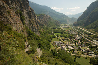 The view towards St-Jean-de-Maurienne from the Lacets de Montveriner. One of the hairpins can be seen in the foreground.
As is so often the case with climbs in the Alps, once the top of the cliff has been reached, the road opens onto an Alpine meadow, continuing up to the village of Montvernier. The residents have taken the Tour very much to heart, with bicycles in evidence throughout the village. Importantly, Montvernier also has drinking water available from a roadside stand pipe and trough.
 Montvernier bedecked with Tour de France icons.
From Montvernier the route curves back around to St-Jean-de-Maurienne. It drops for a while, before kicking up again until the village of Le Chatel is reached, but after that its all downhill to Hermillon, back in the valley. The descent is another nice one with gradients mostly around 6%, plenty of sweeping curves and enough hairpins to keep life interesting. From Hermillon, it's just a matter of retracing your steps back into St-Jean-de-Maurienne.
For me it was a nice, light afternoon ride. Angela managed to get round too, and can now add a Tour de France Category 2 climb to her Palmares! Well done Grandma.
Today's route is available on Garmin Connect.
Part of the idea for today was to give Angela the chance to ride up a categorised Tour de France climb without the need to roam miles from base.
The run from St-Jean-de-Maurienne to the base of the climb is virtually flat, the only difficulty being negotiating an exit from the town via its one way system. The approach to the first ramp hits 10%, but then things settle down to between 7 and 9%. The most remarkable thing about this road is that anyone thought it was a good idea to build it in the first place. Each ramp is so immediately above the previous one that it is impossible to photograph it. In a mere 3 kilometres or so it gives a flavour of the lower reaches of Alpe d'Huez, but at a shrunken scale.

Naturally there are clear views of the Maurienne valley from the climb. It's not the most picturesque at this point though, with transport and industry dominating the scene. It's just amazing that they managed to get a main road, a railway, and an Autoroute into the confines of the valley, especially east of St-Jean-de-Maurienne. And there is a river in there too, of course.

As is so often the case with climbs in the Alps, once the top of the cliff has been reached, the road opens onto an Alpine meadow, continuing up to the village of Montvernier. The residents have taken the Tour very much to heart, with bicycles in evidence throughout the village. Importantly, Montvernier also has drinking water available from a roadside stand pipe and trough.

From Montvernier the route curves back around to St-Jean-de-Maurienne. It drops for a while, before kicking up again until the village of Le Chatel is reached, but after that its all downhill to Hermillon, back in the valley. The descent is another nice one with gradients mostly around 6%, plenty of sweeping curves and enough hairpins to keep life interesting. From Hermillon, it's just a matter of retracing your steps back into St-Jean-de-Maurienne.
For me it was a nice, light afternoon ride. Angela managed to get round too, and can now add a Tour de France Category 2 climb to her Palmares! Well done Grandma.
Today's route is available on Garmin Connect.
Subscribe to:
Comments (Atom)