After three fairly big climbs in a row, I was looking for something a little easier today. After a leisurely breakfast we set about fixing Angela's Garmin, which was steadfastly refusing to register speed and cadence correctly. It was still playing up when we decided there was no more we could do, serviced the bikes and set out on what is known around here as the Tour de Chatel. This involves climbing the Lacets de Montvernier, made famous this year in the Dauphine and the Tour, and descending via the lower reaches of the Col de Chaussy. By the way, Lacets is the French for shoelaces, and is meant to reflect the shape of the hairpin bends folded into the side of the hill.
Part of the idea for today was to give Angela the chance to ride up a categorised Tour de France climb without the need to roam miles from base.
The run from St-Jean-de-Maurienne to the base of the climb is virtually flat, the only difficulty being negotiating an exit from the town via its one way system. The approach to the first ramp hits 10%, but then things settle down to between 7 and 9%. The most remarkable thing about this road is that anyone thought it was a good idea to build it in the first place. Each ramp is so immediately above the previous one that it is impossible to photograph it. In a mere 3 kilometres or so it gives a flavour of the lower reaches of Alpe d'Huez, but at a shrunken scale.
The Lacets de Montvernier, seen on the approach from St-Jean-de-Maurienne.
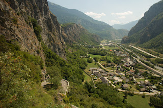
Naturally there are clear views of the Maurienne valley from the climb. It's not the most picturesque at this point though, with transport and industry dominating the scene. It's just amazing that they managed to get a main road, a railway, and an Autoroute into the confines of the valley, especially east of St-Jean-de-Maurienne. And there is a river in there too, of course.
The view towards St-Jean-de-Maurienne from the Lacets de Montveriner. One of the hairpins can be seen in the foreground.
As is so often the case with climbs in the Alps, once the top of the cliff has been reached, the road opens onto an Alpine meadow, continuing up to the village of Montvernier. The residents have taken the Tour very much to heart, with bicycles in evidence throughout the village. Importantly, Montvernier also has drinking water available from a roadside stand pipe and trough.
Montvernier bedecked with Tour de France icons.
From Montvernier the route curves back around to St-Jean-de-Maurienne. It drops for a while, before kicking up again until the village of Le Chatel is reached, but after that its all downhill to Hermillon, back in the valley. The descent is another nice one with gradients mostly around 6%, plenty of sweeping curves and enough hairpins to keep life interesting. From Hermillon, it's just a matter of retracing your steps back into St-Jean-de-Maurienne.
For me it was a nice, light afternoon ride. Angela managed to get round too, and can now add a Tour de France Category 2 climb to her Palmares! Well done Grandma.
Today's route is available on Garmin Connect.


No comments:
Post a Comment